
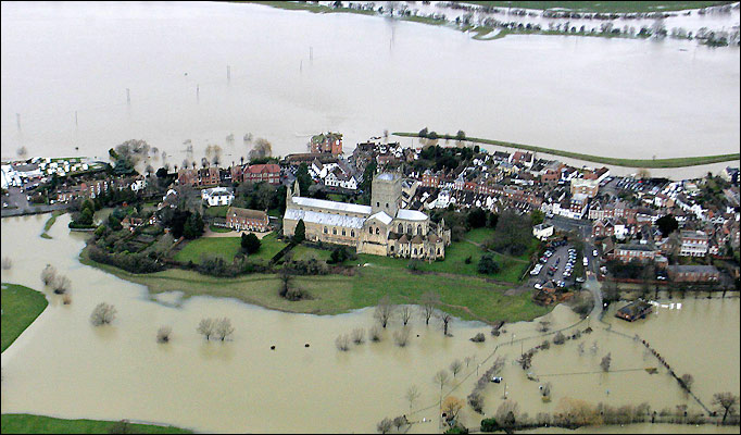
Substantial parts of the UK are in crisis due to flooding. Not a one-off crisis either but repeated floods seem to be hitting Britain as rains come, river banks are breached and homes in the vicinity are left underwater. This is the situation here and now, with risks remaining high, but it’s only 3 years since Workington was left in crisis with bridges over the river Derwent crumbling away. Towns up and down the country are being affected, including places that have never suffered before. There was severe flooding in 2007, and many other years too.
These deluges, people say, are “once in a thousand years” – except that they seem to be recurring with increased frequency, and government and insurance companies are increasingly at odds about who should pay for the damage caused and recompense householders for the inevitable repairs at their homes. We must assume this will happen each and every year, indeed there may even come a time when floodplains will be permanently under water, including villages and towns in the wake of this expanded tide.


Yet Local Authorities are coming under increased pressure to build more homes, with the logical inference that planning applications should be approved with a minimum of scrutiny, by waiving rules and cutting red tape in the process. Indeed, planning laws are being deliberately relaxed to “boost the economy” and, according to deputy PM Nick Clegg, “…lead to more affordable homes.” Indeed, the PM himself said
“This government means business in delivering plans to help people build new homes and kick-start the economy. We’re determined to cut through the bureaucracy that holds us back. That starts with getting the planners off our backs, getting behind the businesses that have the ambition to expand and meeting the aspirations of families that want to buy or improve a home.”
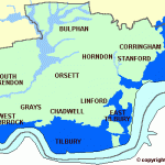
Yet vast numbers, thousands of the cheap homes that the government want to be built are on flood plains. To choose one example, a 2001 Panorama investigation found that the target for Selby is 3,000 new homes. This is what happened:
There are two housing estates side by side at Barlby near Selby in Yorkshire. More than 100 homes on the Wainhomes estate were flooded last November. But only three homes were affected on the Haslam estate. The planners had insisted that floor levels on the Haslam estate should be raised. Wainhomes was not asked to raise its floor levels. When Wainhomes applied for planning permission for this estate the advice about flood risks came from the forerunner of the Environment Agency, the National Rivers Authority. The advice went to Selby District Council.
Richard Borrows from the Council says, “They (the NRA) didn’t recommend refusal which they could have done if they felt there was an overriding flood risk which we shouldn’t discount.”
The NRA say that they advised that careful consideration should be given to the raising of floor levels on the estate. The Council say they passed the advice to Wainhomes. Wainhomes turned down Panorama’s invitation for an interview but in a statement said that the NRA’s advice referred to “adequate facilities for the drainage of surface water” – which they installed – and “not… as a defence against flood water”.
The company said it had acted in good faith and its site was “not shown as a flood risk area in any public document.” Most of the houses, it said, were sold to “local residents who had substantial local knowledge” and the company believes that they too “were not aware of any material flood risk.”
Currently, there is no legal obligation on a council to accept the advice of the Environment Agency about flooding risk. It is the homeowners who suffer most.
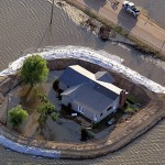
This scenario may have continued in many other areas. The evidence of my own eyes suggests that thousands of houses are being built around my area of Essex in locations vulnerable to flooding, yet without any apparent protection against floods. Given the impact of global warming and higher sea levels, is this not inevitably going to mean cheap homes sold to people who have to deal with the impact of floods on a regular basis, but can’t insure their homes, nor even sell them afterwards?
This is what is said about building on floodplains in the Norfolk Broads area, one of the lowest-lying areas in the country, which illustrates that this whole issue is mired in red tape and grossly underestimated by the authorities responsible:
The Government places an increasingly high emphasis on protecting property and individuals from flood risk. This is partly in response to recent flooding events and partly in response to climate change and the increasing risk of more frequent flood events. A further driver is the need to provide hundreds of thousands of new homes, particularly in the south-east where much development land is within the lower lying areas. The Government has determined that, rather than trying to protect these sites through traditional means such as flood defences, a more fundamental approach is required. It is seeking, therefore, not to allow new development in areas of high flood risk. As a general policy position this is a sensible approach and represents good forward planning. A plan showing the extent of the Flood Zones within the Broads Executive Area is available (pdf) [230 kb], but please note this is a simple representation and you should always approach the Planning Department before considering any development within the Broads Executive Area.
Planning Policy Statement 25: Development and Flood Risk (PPS25) The above approach is set out in Planning Policy Statement 25: Development and Flood Risk (PPS25). PPS25 is a Government document representing Government policy, published in December 2006 and later in a companion guide published in July 2008. The implementation of PPS25 is overseen by the Environment Agency in their advice on, and response to, planning applications. All local planning authorities across the country, including the Broads Authority, are required to adhere to it. Therefore, although PPS25 is not a policy statement by the Broads Authority, we are required to abide by it.
PPS25 classifies development according to its vulnerability to flooding, ranging from ‘water compatible uses’ to ‘highly vulnerable uses’. It divides the country up into one of four flood risk zones (1, 2, 3a and 3b) ranging from low flood risk (Flood Risk Zone 1) to functional flood plain (Flood Risk Zone 3b). It then provides a matrix setting out what types of development are appropriate in each flood risk zone. The boundaries of the various flood risk zones have been published in the Broads Strategic Flood Risk Assessment (SFRA). The SFRA will be available via the Greater Norwich Development Partnership website and may also be viewed at the Authority’s offices.
Local policy on development and flood risk
In September 2008, the Authority published a Development and Flood Risk Supplementary Planning Document (SPD) (pdf) [213kb] as part of its Local Development Framework. The SPD provides guidance to developers and planning applicants on management of flood risk and the particular circumstances for allowing development in The Broads.Broads planning policies favour development which contributes to the economic function of the area such as agriculture, tourism (including hotels and holiday accommodation) and the marine industry, or for environmental purposes. The policies are not looking for the provision of sites for new residential development. A proposal for permanent residential development on previously undeveloped land in Flood Risk Zone 3 is most unlikely to pass the Sequential Test. It is expected that, as most developed land in The Broads lies within Flood Risk Zone 3, an ‘Exception Test’ will need to be applied for most applications for new development which are compatible, in principle, with their location in The Broads. The SPD clarifies how the test will be interpreted locally.
In general, it is unlikely that development will be permitted on ‘green field’ sites in the flood plain. In Flood Risk Zone 3b, new water compatible development or a like-for-like replacement of an existing use may be appropriate. In Flood Risk Zone 3a, which includes previously developed land shown on the SFRA as being in functional flood plain, new development for water compatible uses or less vulnerable uses (as defined in PPS25) or a like-for-like replacement of an existing use may be permissable under certain circumstances.
Sustainable drainage systems (SUDS) are the best way of avoiding and managing surface water flooding if new development cannot be located away from the flood risk area. The SPD outlines how the Authority would expect to see sustainable drainage accommodated in a development. Developers should assess carefully the full range of issues associated with flood risk when considering and formulating development proposals. They should take into consideration the effects of climate change over the lifetime of the proposed development. Pre-application discussion of these issues with officers of the Broads Authority and the Environment Agency is strongly encouraged. Developers must demonstrate that development both minimises flood risk and will still be of a scale and design appropriate to its Broads setting. There is a particular need for a good quality of design when dealing with waterside sites.
In short, there is a legal requirement for all concerned to protect against flooding, but the results speak for themselves. It’s always too little, too late. Yet there are now so many of these areas, covering such a huge area that the following facts are self-evident:
- Governments cannot meet their own targets for housebuilding to meet demand for affordable housing without building on flood plains
- Methods used to protect against floods have materially failed or found to be insufficient – not least new flood defence systems, which seem only to have led to complacency on this issue that stopped people planning for floods
- Developers are not building in further protection, probably as a cost-saving measure
- The climatic conditions that lead to severe weather and flooding are likely to get worse, so this problem will self-perpetuate – yet it always seems to take our authorities and householders by surprise
- Advice on how to protect your home is rarely taken, but is in any case inadequate against the severity of conditions.
Clearly more radical steps without the need for complex bureaucracy is the answer, but rather than arguing the toss about policy documents it should be practical and innovative steps that enforce effective planning. For example, there are plenty of options for dealing with building on floodplains:
- Go out to the islands on the Gulf coast in Florida and you’ll find houses built on stilts. Granted they wouldn’t survive a hurricane, but in that case you simply rebuild your wooden house – and hurricanes are not an issue in the UK anyway!
- Floating homes are one novel solution.
- Other forms of flood-proof housing are being suggested by the RIBA
- The Netherlands manages to build houses and protect against floods in spite of the vast majority of its land mass being below sea level – why are we not taking note of the methods used there?
So why are some of these measures not actually implemented? Presumably the industry is bleating about costs, though the costs of dealing with floods in hindsight are far costlier than taking effective precautions. Why is it always too little, too late?
Way cool! Some extremely valid points! I appreciate you
penning this post and also the rest of the website is extremely good.
I feel that is among the such a lot important info for me. And i’m satisfied reading your article. However want to statement on some normal things, The website taste is ideal, the articles is in reality excellent : D. Just right job, cheers